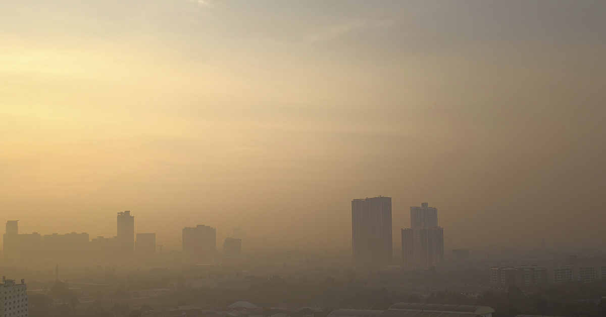

The US Environmental Protection Agency issued an urgent warning to more than 1.3 million residents across Texas and New Mexico. Due to the severe drop in air quality, residents are urged to stay indoors, shut their windows, and avoid outdoor exercise. The US EPA issued the warning last week, Friday, 27th March 2026. Two clouds of hazardous particulate matter formed at the same time, covering nearly 500 miles in total. The event ranked parts of the American South among the most polluted areas on Earth at the time of measurement. For many residents along the US-Mexico border, the warning came as no surprise. It was the latest chapter in a deteriorating air quality story, according to researchers, now extends beyond the weather.
The Alert and What It Covered
On March 27, the EPA pinpointed two separate hazardous areas across the American South using its real-time monitoring network. One plume originated in Fort Stockton, located in southern Texas, and traveled approximately 300 miles north to Friona, a small city in the Texas panhandle near the New Mexico border. This single zone placed more than 600,000 residents in Texas and New Mexico at immediate risk. Major cities caught inside the cloud included Lubbock, Midland, and Odessa, all situated within or adjacent to the Permian Basin, the largest oil and gas producing region in the United States. The air quality-tracking platform IQAir reported multiple pollution-causing fires just outside Odessa, with local wind patterns pushing hazardous particles north into the wider region.
The Deadlier Zone to the West
By 2 pm ET on 27 March, a second and more dangerous plume had formed to the west. This cloud stretched nearly 200 miles across the Texas-New Mexico border with Mexico, centered directly over El Paso, which has a population of nearly 700,000 people. The EPA classified several areas within this zone as “hazardous,” the most severe air quality classification.
At its peak that morning, monitoring stations near El Paso recorded an air quality index of 290, putting it in the “very unhealthy” category and briefly ranking it as the worst air quality of any major city in the world at the time. By 2 p.m. ET, IQAir had recorded an AQI of 174 for the El Paso area, which remained in the “unhealthy” range for all members of the public. PM2.5 levels in Sunland Park, New Mexico, on El Paso’s southern outskirts, increased to more than four times the World Health Organization’s recommended safe limits.
What Officials Told Residents
To protect their health, residents in either of the impacted regions were strongly cautioned by the EPA to keep windows shut, refrain from exercising outdoors, use air purifiers when possible, and wear face masks if they needed to go outside. The Texas Commission on Environmental Quality separately confirmed that PM10 levels in El Paso had also reached unhealthy thresholds on the same day, compounding the health risk from PM2.5 already saturating the air. In Odessa, IQAir stations recorded PM2.5 levels more than 18 times the WHO-recommended safe limits at 1 point during the morning of the 27th.
Understanding the AQI Scale
The EPA measures air quality on a standardized numerical scale running from 0 to 500. Readings from 0 to 50 are classified as “good” and carry little public health risk for any segment of the population. The range from 51 to 100 is “moderate” and may affect unusually sensitive individuals. Between 101 and 150, the designation shifts to “unhealthy for sensitive groups,” posing increased risk for children, the elderly, and those with pre-existing conditions. Above 151, the air is classified as “unhealthy” for everyone, limiting outdoor activity. Readings above 200 are “very unhealthy,” and anything above 300 triggers emergency health warnings for the public. On 27 March, El Paso briefly registered 290, just below the emergency threshold, while simultaneously posting the worst reading of any major city in the world at that specific moment.
What These Particles Do to the Body
The EPA identifies fine particulate matter, or PM2.5, as a leading threat among air pollutants. These particles, measuring less than 2.5 micrometers in diameter, are much smaller than a human hair and can bypass the respiratory system’s natural filters when concentrations rise. Once people inhale PM2.5, it travels deep into the lungs, enters the bloodstream, and eventually reaches vital organs like the heart and brain. Research from the EPA links such exposure to premature death and serious cardiovascular conditions, including accelerated arterial disease and irregular heart rhythms. The WHO reports that ambient outdoor air pollution, primarily driven by PM2.5, led to 4.2 million premature deaths in 2019.
Cardiovascular and Respiratory Consequences
The American Heart Association’s peer-reviewed research in Circulation shows that short-term exposure to PM2.5, lasting from hours to weeks, can cause irregular heart rhythms, non-fatal heart attacks, and even death from cardiovascular disease. People living in highly polluted areas experience long-term exposure that reduces their life expectancy by months or years. Additionally, a 2022 study in Frontiers in Endocrinology found that both chronic and acute exposure to PM2.5 act as independent risk factors for stroke, heart failure, thrombosis, and ischemic heart disease, impacting even those without prior health issues. The 2024 State of Global Air report by the Health Effects Institute states that air pollution has become the second most significant risk factor for mortality worldwide, contributing to 8.1 million deaths in 2021. A large portion of the disease burden from air pollution, up to 90%, includes conditions such as lung cancer, diabetes, COPD, stroke, and heart disease.
The Specific Risks for Children
Children are particularly vulnerable to high levels of toxicity in the air and at risk of an array of hazards. Because their lungs are still in the developmental phase, exposure to PM2.5 during these critical years results in significant and irreversible harm. The WHO has established a connection between early childhood air pollution exposure and issues such as premature birth, low birth weight, and impaired brain development, as well as chronic conditions like asthma and lung disease that continue into adulthood. According to the State of Global Air 2024 report, air pollution was the second most significant global risk factor for mortality in children under five, tied to 709,000 deaths in 2021.
A 2025 study published in JMIR Public Health Surveillance found a significant link between prolonged PM2.5 exposure and precocious puberty in girls, adding developmental interference to the already serious health outcomes for children. Students in El Paso live directly in this ongoing pollution zone. Research has shown that living in areas with toxic air in El Paso leads to lower academic achievement. In fact, the American Lung Association ranked the city eighth among 277 U.S. metropolitan regions for annual particulate pollution as recently as 2014.
PM10 and the Compounding Problem
PM10 particles contribute to respiratory harm and danger. These particles, which are larger than PM2.5, measure under 10 micrometers. They primarily originate from industrial emissions, soot, smoke, pollen, construction debris, and dust. The Texas Commission on Environmental Quality confirmed that PM10 concentrations in El Paso reached unhealthy levels concurrently with the PM2.5 alert. People can inhale both types of particulate matter deep into their lungs, where they worsen asthma and are linked to premature death with prolonged exposure. El Paso’s location downwind from the Chihuahuan Desert, the manufacturing corridor around Ciudad Juárez, and heavy border traffic make it particularly vulnerable to PM10. The simultaneous presence of PM2.5 and PM10 creates a cumulative respiratory strain that exceeds the individual risk posed by either pollutant.
Why the Southern Border Keeps Failing
El Paso faced an air quality crisis in March 2026, following a noticeable decline in the region’s atmospheric health. IQAir’s annual World Air Quality Report, released in March 2026 and based on data from the previous year, named El Paso the most polluted major city in the United States. This ranking resulted from a significant increase in the city’s average PM2.5 concentrations, which rose nearly 46% in just one year, going from 7.8 micrograms per cubic meter in 2024 to 11.4 in 2025.
Dr. Christi Chester-Schroeder, lead author of the IQAir report and senior air quality science manager at the organization, stated, “We saw an almost 300% increase in PM2.5 concentrations compared to the previous year.” According to the American Lung Association’s 2025 State of the Air report, El Paso received an “F” grade for ozone pollution, placing the metropolitan area 14th worst in the country. This assessment follows a year when the city’s particulate baseline was already the poorest in the nation; the data accounts for the 2025 spring dust seasons rather than the specific event in March 2026.
Geography as a Trap
El Paso lies in a low-lying basin along the Rio Grande, bordered by the Franklin Mountains to the north and the vast Chihuahuan Desert to the south. This geography traps pollutants, as winds funnel particles into the city and press them against the mountain range with little dispersal. The Chihuahuan Desert, one of North America’s most active dust generation zones, significantly impacts the region.
A January 2025 study in Nature Sustainability, co-authored by UTEP professor Thomas Gill, estimates that wind erosion and dust storms cost the US economy $154 billion annually, affecting sectors like healthcare, agriculture, transportation, renewable energy, and households. Gill describes this as a conservative estimate, noting it represents a fourfold increase since the last major assessment in the 1990s. From March to June, El Paso experiences its dust season, facing its most hazardous air quality when drought and heat peak each year.
Climate Change Is Accelerating the Problem
Investigations by Inside Climate News in 2025 showed that dust storm frequencies in El Paso reached levels not seen since the Dust Bowl. Researchers identified rising temperatures, persistent drought, and desiccated soil as the main factors driving this increase. In early 2025, an unusually hot and dry period combined with intensified winds caused daily particulate pollution to hit its highest point for that season since 2000, according to data from the EPA monitor at Hueco Elementary School in Socorro.
In February 2025, UTEP Professor Thomas Gill predicted that the peak dust season from March through June would bring frequent events to El Paso, and this forecast came true just weeks later. Additionally, the IQAir 2026 World Air Quality Report stated that dust storms and climate-linked wildfires significantly raised air pollution across the U.S. during 2025. The report highlighted that geographical distance from a source offers little safety, as weather patterns now regularly transport hazardous particles across state and international boundaries.
The Juárez Industrial Corridor
The massive industrial presence of Ciudad Juárez, located just across the border, worsens the air quality challenges in El Paso. Juárez, with a population exceeding 1.6 million, hosts 321 active maquiladora manufacturing facilities that focus on electronics, automotive, and medical device sectors. However, environmental oversight in this industrial corridor remains significantly inadequate. A January 2026 study by MexicoNow found that only 31% of these plants have approved environmental impact resolutions.
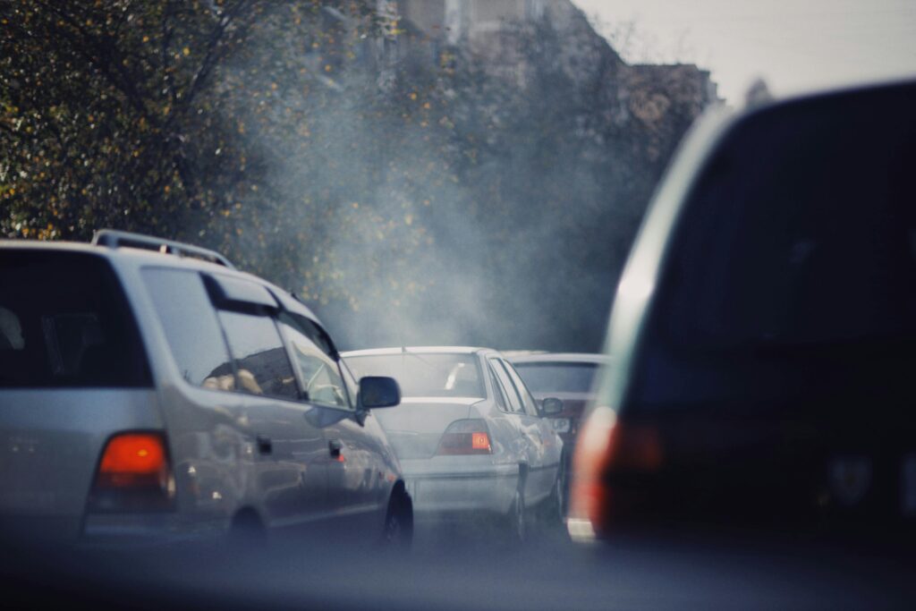
As a result, nearly 70% of Juárez’s industrial sites operate without the necessary government authorization to evaluate their waste management, air emissions, or the ecological impact on nearby residents. Heavy border traffic also increases regional pollution. In 2018, the El Paso port of entry recorded over 2 million northbound cars and 844,000 trucks. This high volume of transit occurs within one of North America’s most geographically restricted air basins, creating a constant level of vehicular emissions that continues regardless of specific dust storms or fire incidents.
A Pattern of Alerts and a Shrinking Safety Net
The southern border region has experienced several air quality crises in early 2026, making the March event part of a broader, concerning trend. In January 2026, a similar corridor across Texas, New Mexico, and Arizona recorded “unhealthy” PM2.5 levels, prompting stay-indoors advisories for thousands of residents. In February 2026, a multi-state alert extended as far as Pennsylvania and California, with El Paso again identified as a primary impact zone.
Newsweek reported that millions across 4 states received advice to seal their windows against hazardous air during this time. These frequent alerts indicate a systemic failure rather than a series of random weather incidents. The region’s unique geography, high industrial output, cross-border pollution, and worsening climate conditions combine to create a perfect storm, making these hazardous events more common and intense.
Federal Budget Cuts Threaten Monitoring Capacity
Federal budget decisions now directly threaten the capacity to detect, track, and respond to these events. In January 2026, Congress passed a spending bill that cut EPA funding by 4%, bringing the agency back to 2012 funding levels when adjusted for inflation. President Trump’s proposed FY2026 budget goes even further, calling for a 55% reduction in EPA funding, which includes a $1 billion cut to EPA grant programs that support air monitoring systems in communities nationwide. Local environmental groups in the Dallas-Fort Worth area reported in February 2026 that DOGE-linked EPA grant cuts had already removed air monitoring systems in 9 communities across the Metroplex.
Texas environmental organizations view these cuts as a direct threat to the early warning systems that alert residents when conditions similar to those on March 27 begin to develop. The Surfrider Foundation pointed out that the proposed cuts would also reduce NOAA’s critical atmospheric monitoring capacity, limiting the national government’s ability to forecast dangerous air quality events days in advance. With less monitoring, the number of alerts decreases, public health responses slow down, and the ability to protect the 1.3 million people who will find themselves in the next hazardous air event diminishes.
New Mexico’s Own Failing Report Card
El Paso’s problems do not stop at the Texas state line. New Mexico’s metropolitan areas rank among the worst for air quality in the nation, according to the American Lung Association’s 2025 State of the Air report. The Las Cruces metro area, which borders El Paso and sits directly inside the same pollution corridor, ranked 18th nationally for ozone pollution and received an “F” grade in the same assessment.
The New Mexico Political Report noted that two New Mexico metropolitan areas ranked in the top 25 most polluted in the country in 2025. Not a single county in New Mexico received an “A” grade for either ozone or particle pollution in the 2025 State of the Air report. The region from El Paso north through Las Cruces and Albuquerque is, by every major measurement, one of the most chronically polluted corridors in the United States. March 2026 did not create that reality. It made it visible, briefly, to 1.3 million people told to lock their windows and wait.
A.I. Disclaimer: This article was created with AI assistance and edited by a human for accuracy and clarity.
Read More: Trader Joe’s Recalls Popular Product After Selling 9M+ Pounds Across 43 States