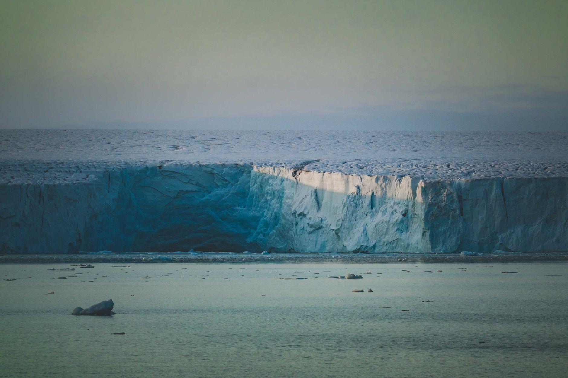

The 2,000-kilometer arc of Antarctic coastline that curves along East Antarctica’s northern edge forms a nearly perfect semicircle when viewed from above. That geometry is no accident. Buried beneath the ice lies a geological structure that researchers had been examining piece by piece for decades without ever recognizing it as a single, unified system.
In June 2026, an international research team published findings that reframe everything scientists thought they knew about the buried geology beneath East Antarctica’s ice sheet. What had long been catalogued as a collection of separate subglacial basins – deep depressions in the bedrock buried under kilometers of ice – are actually components of a single, continent-scale structure. Its identification changes the picture of Antarctica’s deep geological past, and it carries direct implications for how the ice sheet above it behaves today.
The discovery did not emerge from a single dramatic expedition. It came from the patient synthesis of decades of radar surveys, gravity measurements, magnetic anomaly data, and seismic profiles, reinterpreted through a new analytical lens that revealed an architecture no one had explicitly looked for before.
The Structure Beneath the Antarctic Ice
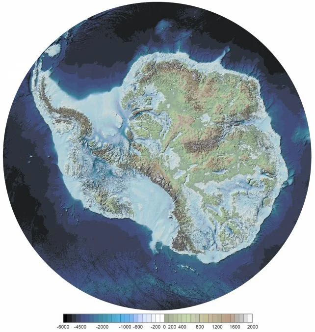
Beneath East Antarctica, a team led by geophysicist Dr. Egidio Armadillo of the University of Genoa identified an enormous, fan-shaped province of about 30 connected basins. It widens toward the coast, as though someone had taken a corner of Antarctica and tugged it apart around a central inland pivot point. The researchers named it the East Antarctic Fan-Shaped Basin Province (EAFBP), and they propose that it formed before the breakup of the Gondwana supercontinent, creating a zone of weakness that may later have helped steer the separation of Antarctica and Australia.
The team’s study, titled “A fan-shaped subglacial basin province in East Antarctica formed by rotational extension,” was published in Nature Geoscience on June 3, 2026. The research involved institutions from Italy, Switzerland, Germany, and the United Kingdom, with Durham University’s Department of Geography playing a key role. The work was led by Dr. Armadillo and was supported by the Italian National Antarctic Research Program.
The newly recognized structure consists of a network of enormous basins concealed beneath ice that exceeds three kilometers (nearly two miles) in thickness in some locations. The two primary components, the Wilkes Basin and the Aurora Basin, each extend more than 1,500 kilometers from the Antarctic coastline toward the deep interior. At its widest, the province spans the continent from Prydz Bay at 70 degrees east longitude to the Transantarctic Mountains at 160 degrees east, a horizontal reach of roughly 90 degrees of longitude at those latitudes.
Recent sub-ice topography investigations have imaged a set of low-elevation V-shaped basins hidden beneath a very large sector of the East Antarctic Ice Sheet. These basins form a semi-continental-sized, fan-shaped physiographic unit that radiates from a focal point near the South Pole.
The scale of the structure is one of its most striking features. A radial system of buried triangular basins beneath the East Antarctic Ice Sheet may record continent-scale rotational extension, revealing a hidden tectonic architecture that shaped the subglacial landscape and influenced both the later Antarctica-Australia breakup and ice-sheet evolution.
Known Features, Unrecognized Connection
The province includes some of Antarctica’s best-known subglacial features, among them the Wilkes and Aurora basins and the basin hosting Lake Vostok, the largest known subglacial lake on Earth. Although these basins have been individually studied in the past, this is the first time their connection as part of a single coherent structure has been recognized.
Lake Vostok is a useful illustration of just how hidden this buried world truly is. Buried approximately four kilometers beneath Russia’s Vostok Station, it stretches more than 240 kilometers in length and holds around 5,400 cubic kilometers of water. Dr. Guy Paxman from Durham University’s Department of Geography contributed calculations estimating how East Antarctica’s landscape would appear if the entire ice sheet were removed – a process that would cause the land to rebound upward by as much as one kilometer as the weight of the ice lifted. This reconstructed “rebounded topography” allowed researchers to examine both the elevation and orientation of the newly identified geological structure.
There are an estimated 27 million cubic kilometers of ice covering Antarctica, and it doesn’t just sit passively on the rock beneath. All that mass pushes the bedrock downward. Mapping what’s actually beneath the ice, as opposed to what radar images simply show, requires reconstructing that compressed bedrock into its unloaded state. That calculation is what allowed the fan-shaped geometry to become visible in the first place.
As Dr. Armadillo and his colleagues noted, “Antarctic bedrock is largely obscured by the Antarctic Ice Sheet, which covers more than 99% of the continent.” International compilations of radio-echo sounding surveys have resolved large-scale subglacial topographic features in increasing detail, “revealing a wide and low-elevation sector of East Antarctica extending from Prydz Bay to the Transantarctic Mountains and from the coast inland to 85° S.”
Using a decade of data from the European Space Agency’s CryoSat-2 radar altimetry satellite, researchers detected 85 active subglacial lakes in Antarctica in a study published in September 2025. Those observations increased the number of known active subglacial lakes in Antarctica by 58%. As a broader inventory, radio-echo sounding surveys have detected 773 subglacial lakes globally, 675 of them in Antarctica.
How the Earth Pulled Itself Apart
The mechanism that created this structure is called distributed rotational extension, a process in which continental crust stretches outward from a central fixed point, like fingers spreading from a palm. The pattern resembles a hand, with the base of the thumb as the fixed point and the fingers spread wide showing the direction of stretching. The gaps between the fingers are the triangular basins that form as the crust opens.
Findings published in the same Nature Geoscience paper quantify the structure’s geometry through a combination of subglacial radar surveys, gravity measurements, magnetic anomaly data, and seismic velocity models, tracing its origin to rotational extension that operated during the breakup of the ancient supercontinent Gondwana somewhere between 90 and 150 million years ago.
The East Antarctic Fan-Shaped Basin Province could be one of the largest examples of rotational extension ever seen in continental crust. It may have developed through multiple tectonic phases linked to the evolution of the Gondwana supercontinent and the later separation between Antarctica and Australia, and could even have influenced that breakup.
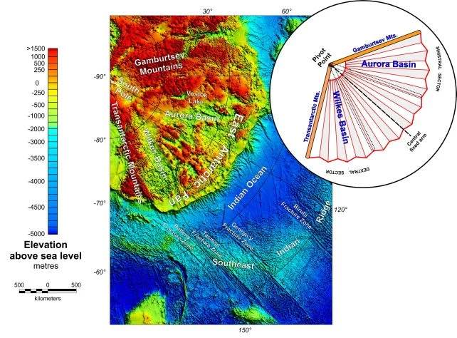
The process had effects far beyond the formation of the basins themselves. The fan-like landscape is the product of distributed intraplate rotational extension before the breakup of Gondwana, with three continental-scale consequences. Laterally, to the west, it caused compression and the consequent uplift of the Gamburtsev Mountains. To the east, the northernmost Transantarctic Mountains segment rotated clockwise by approximately 20 degrees, overriding the West Antarctic Rift System’s hot lithosphere and causing segmentation of the mountain chain into three blocks.
The Gamburtsev Subglacial Mountains, a completely buried range roughly the size of the European Alps, were first detected by Soviet scientists in 1958, and their origin had long puzzled geologists. The new research provides a unifying tectonic explanation connecting their formation to the same rotational forces that shaped the EAFBP.
According to Durham University, the province takes in several well-known subglacial features, including the Wilkes and Aurora basins and the basin that holds Lake Vostok. Although many of these basins have been examined individually for years, this is the first time they have been recognized as parts of a single, interconnected whole.
Australia’s separation from Antarctica adds another layer to this story. The province may have influenced the breakup between Antarctica and Australia. According to Australia’s Antarctic Division, Australia began separating from Antarctica roughly 85 million years ago, with full oceanic separation completed around 30 million years ago, a timeline that tracks closely with the tectonic phases the researchers identified in the EAFBP.
The Bedrock Still Shapes the Ice Above
The buried geometry of these basins actively influences how ice flows across the continent today, and that has direct relevance to sea-level science. As the researchers write in their paper: “Because these basins underlie about half of the East Antarctic Ice Sheet, they are likely to heavily influence both ice-flow and landscape evolution, making them essential to Antarctic glacial and hydrological processes.”
The bedrock below an ice sheet acts like a tray holding water. Tilt the tray, lower parts of it, or carve channels into it, and the fluid above responds accordingly. Where the bedrock dips into deep basins, ice can become grounded below sea level, a configuration that makes it particularly vulnerable to marine incursion and potential instability. Marine-based sectors in East Antarctica represent approximately 5 meters of potential sea-level rise, and research suggests they are at risk of losing stability at 2 to 5 degrees Celsius of global warming.
The East Antarctic ice sheet has long been considered the more stable of Antarctica’s two major ice masses, but the geometry of its buried bedrock complicates that assumption considerably. Depending on topographic and climatic conditions, ice loss in some basins unfolds gradually with warming, whereas other basins have a critical threshold or tipping point beyond which large parts eventually disintegrate.
A broader accounting of the Antarctic ice sheet’s current trajectory reinforces why bedrock structure matters. Between 1979 and the end of 2024, the Antarctic Ice Sheet lost a total of 4,876 ± 530 Gt of ice, contributing 13.5 ± 1.5 mm to global mean sea-level rise, with losses dramatically increasing over the satellite record. The majority of this mass loss originates from West Antarctica (84%), where glaciers such as Thwaites and Pine Island have experienced an acceleration in thinning, flow, and grounding line retreat. According to Copernicus Climate Change Service data, Antarctica lost 82 Gt of ice in 2024 alone.
Antarctica’s ice sheet could contribute 28 centimeters to sea level by 2100, and potentially more if warming surpasses thresholds that trigger instabilities and rapid retreat. Ice-sheet models that fail to incorporate the connectivity and geometry of the EAFBP may be misrepresenting how ice in this region will respond to warming, which is precisely why the structural discovery carries practical weight beyond its geological interest. You can read more about recent Antarctic ice loss and what the numbers actually mean for sea-level projections.
Subglacial Water as an Ice Accelerant
The EAFBP also reframes scientific understanding of subglacial hydrology, the water systems that exist at the base of the ice. Subglacial water acts as a lubricant between ice and bedrock. When it drains rapidly through connected basin systems, it can accelerate ice flow and increase the rate at which ice discharges into the ocean. Subglacial lake activity influences ice sheet flow, grounding line discharge, and ice shelf basal melting.
CryoSat-2 observations, published in Nature Communications in September 2025, identified five subglacial lake networks with concurrent upstream drainage and downstream filling, and 25 clusters of lakes, improving knowledge of interconnected subglacial hydrological pathways. The EAFBP’s newly recognized connectivity suggests these drainage networks may be far more extensive and structurally organized than previously assumed.
Research published in Nature Communications in April 2025 confirmed that water at the base of ice sheets influences sliding behavior, meaning the distribution and movement of subglacial water directly affects how quickly ice flows toward the sea. The basin architecture of the EAFBP, a system of interconnected depressions covering roughly half of the East Antarctic Ice Sheet, provides exactly the kind of organized topographic plumbing that could concentrate and route that water at continental scale.
What the Study Changes
Prior to this research, scientists studying the Wilkes Basin, the Aurora Basin, or the Lake Vostok basin were, in effect, examining three fingers on a hand without realizing the hand existed. The team has now shown that features long treated as separate are better understood as one: a single, sprawling structure that shaped the continent and continues, quietly, to shape its ice.
To investigate the newly recognized structure, researchers combined multiple sources of data, including subglacial topography, geological observations, gravity measurements, magnetic data, seismic information, and models of the crust and lithosphere. Their analysis indicates that the feature resulted from deep tectonic processes operating within the Antarctic lithosphere.
The geological record embedded in this structure also holds open questions that the authors explicitly acknowledge. The precise age of each individual basin, the exact sequence of tectonic events that produced the province, and the detailed connections between subglacial lakes and the basin network all remain areas for future investigation. Rock samples from most of the region have never been collected, because the ice above is simply too thick and the logistics too demanding.
What This Means for You
The identification of the East Antarctic Fan-Shaped Basin Province is one of the most consequential structural discoveries in Antarctic geology in decades. It did not come from a new technology or a dramatic field campaign. It came from re-examining existing data with a different question in mind, and recognizing that basins previously catalogued as individual features share a single, unifying origin.
The structure’s tectonic history, rooted in the breakup of Gondwana between 90 and 150 million years ago, explains the shape of much of East Antarctica’s buried bedrock and, by extension, the shape of its ice sheet. According to the Nature Geoscience paper, the region beneath the East Antarctic Ice Sheet experienced rotational extension tectonics before the breakup of Gondwana, which shaped the lithosphere and later development of overlying ice.
For climate projections, the practical implication is concrete: major knowledge gaps in critical processes spanning the atmosphere, ocean, ice sheets, underlying beds, ice shelves, and sea ice create uncertainties in future projections that hinder climate adaptation and risk assessments. The EAFBP’s recognition narrows one of those gaps significantly. Beneath three kilometers of ice, East Antarctica held one of the largest geological structures on the planet, catalogued in pieces for decades but never seen whole until now.
AI Disclaimer: This article was created with the assistance of AI tools and reviewed by a human editor.
Read More: Camera Lowered Into Hole 93 Meters Beneath Antarctica Makes Stunning Discovery