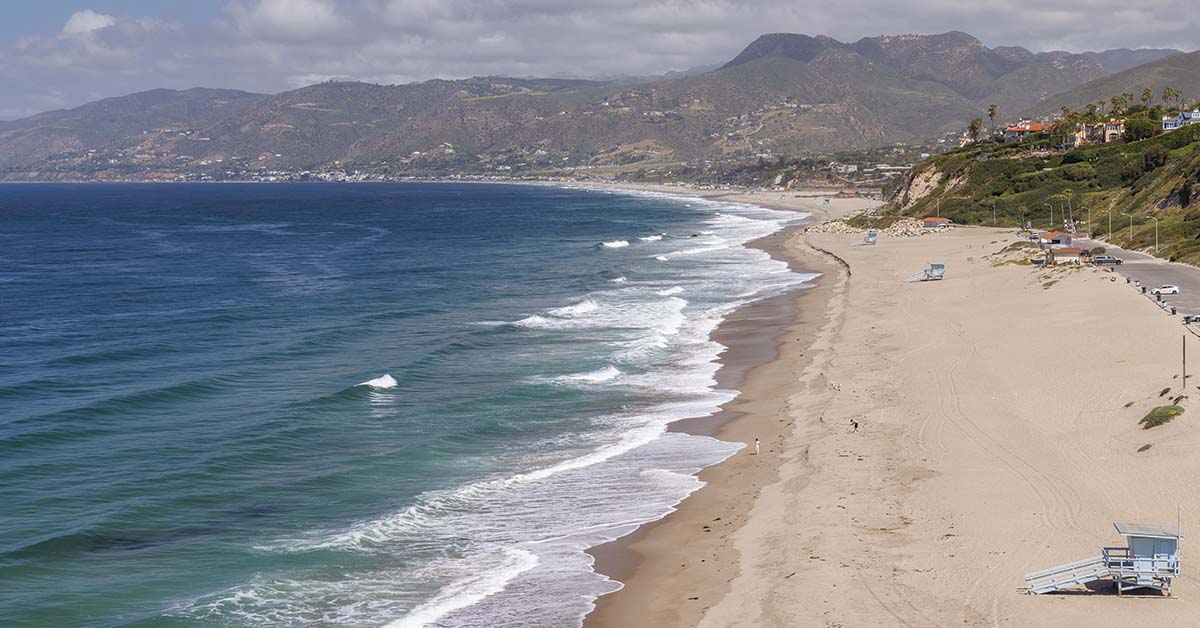

Los Angeles, situated in a state with over 39 million residents, ranks as one of the most densely populated urban centers in the United States. The state’s coastal geography profoundly shapes California’s economic and cultural identity. In the past, before the advent of commercial flight, the proximity of a city to the sea was the primary factor in determining its level of success in terms of commerce and trade. Despite this, new data from NASA indicates that coastal cities in the United States are sinking into the ocean.
Scientists have been watching closely
An alarming new piece of information regarding the coastline of California was recently disclosed by a research team that was led by NASA and published in the journal Science Advances. High-resolution tracking of vertical land movement, including uplift and subsidence, was used in this study, which was peer-reviewed and included specialists from the National Oceanic and Atmospheric Administration (NOAA) and the Jet Propulsion Laboratory (JPL). The study covered the period of time from 2015 to 2023. To highlight trends that have caused significant concern among government officials and members of the scientific community, the team was able to pinpoint specific locations where the Earth is sinking beneath major metropolitan areas. These locations include San Diego, San Francisco, and Los Angeles.
The problem compounds existing risks
Over the course of several decades, researchers have been monitoring the phenomenon of subsidence, which refers to the gradual sinking of the earth, across major metropolitan centers in the United States. In addition, scientists have been warning authorities for a long time about the ongoing decline of New York City and Long Island, which is located nearby, into the waters that surround them. The cumulative weight of New York City’s 1.68 trillion pounds of buildings and skyscrapers pressing into soft, waterlogged ground is a contributing factor in the city’s natural sinking process, which occurs at an average rate of 1 to 2 millimeters per year. The extraction of groundwater, on the other hand, is one of the primary causes of the sinking, as stated by the California Department of Water Resources, with a particular emphasis on the cities of Los Angeles and San Francisco.
What the Research Found
Interferometric synthetic aperture radar (InSAR) was used by a team comprising representatives from NASA and NOAA to monitor the coastline of California, which stretches 1,000 miles, over 8 years. This advanced remote sensing technology aggregates diverse 3D observations to identify ground movement with sub-inch precision. Their comprehensive dataset integrated satellite information from the European Space Agency’s Sentinel-1 with data from Global Navigation Satellite System-connected ground stations.
The numbers point to a doubling effect
By the year 2050, it is anticipated that the sea level in the state of California will rise between 6 and 14.5 inches as compared to the levels that were present in the year 2000. The primary factors that are contributing to this increase are the melting of glaciers and the rising temperatures of the water in the ocean. When scientists consider the phenomenon of localized land sinking, however, the picture takes a significant turn for the better. “Our findings reveal that regional estimates substantially understate sea level rise in parts of San Francisco and Los Angeles, projecting more than double the expected rise by 2050,” the study’s authors stated. As a result of this change, the lives of millions of residents will be directly altered.
Specific hotspots identified in the Bay Area
According to the findings of the researchers, the San Francisco Bay Area is a significant area of concentration for these concerns. Several communities, including Bay Farm Island, Foster City, Corte Madera, and San Rafael, are experiencing subsidence at rates that are greater than 0.4 inches (10 millimeters) on an annual basis. This sinking is largely attributable to the sediment compaction that occurs in landfill and reclaimed land districts. Consequently, by the year 2050, the low-lying areas in these regions that are the most susceptible to the effects of climate change could experience local sea level increases of more than 17 inches (45 centimeters). The previous regional estimate of 7.4 inches (19 centimeters) has been more than doubled by this updated projection.
The Human Factor Behind the Sinking

The most significant contributors to subsidence in the state of California are the excessive extraction of groundwater. In situations where water is extracted from underground aquifer systems at a rate that exceeds the rate at which natural replenishment can take place, the structural integrity of the subsurface soil and rock is compromised. This results in irreversible compaction, which ultimately leads to the surface land sinking in a permanent manner. The gravity of this problem in the San Joaquin Valley of California is brought to light by a study that was conducted at Stanford University and published in Nature Communications Earth and Environment in November of 2024. Over the course of several time periods beginning in 2006, the data indicates that excessive pumping has caused subsidence rates to exceed 1 foot per year.
Human activity worsens what nature started
Smart Water Magazine reported in November 2025 that because these environmental shifts are man-made, the responsibility for creating effective mitigation strategies falls directly on government leaders. Although the surface of the Earth has naturally shifted over the course of time as a result of tectonic movements, new data from NASA confirms that the current rate of sinking is primarily driven by human intervention. In the counties of San Diego and Los Angeles, industrial practices, particularly aggressive groundwater removal and hydrocarbon extraction, have introduced a significant amount of volatility into climate modeling. Regarding sea level projections for the year 2050, these anthropogenic factors are responsible for adding another 15 inches (40 centimeters) of uncertainty.
Newport Beach and Long Beach face localized risk
The coastal communities of Southern California are especially susceptible to the effects of these trends. An analysis of the risks associated with the NASA study indicates that Newport Island, Belmont Shores, and Shoreline Marina are critical areas where localized land motion is contributing to the rise in sea level. In addition to the 0.17 meters of relative sea level rise that tide gauges have already predicted for the year 2050, sinking adds 0.05 to 0.15 meters of rise. Coastal communities, which primarily build on reclaimed land, experience sediment compaction issues akin to those in the San Francisco Bay Area, creating a “one-two punch” of rising water and sinking land.
Life and Infrastructure Under Threat

In a JPL press release, NASA Jet Propulsion Laboratory landslide scientist Alexander Handwerger highlighted the gravity of the situation. He pointed to the Palos Verdes Peninsula in Los Angeles, where aerial radar tracking revealed a 16-inch shift toward the ocean in just 4 weeks. Handwerger cautioned that such velocity poses a direct threat to infrastructure and human safety. This warning underscores a broader trend of ground instability that endangers coastal communities throughout California.
Flood risk expands beyond current projections
A study conducted in March 2024 and published in Nature examined 32 major coastal cities in the United States. The study found that land subsidence, with projected sea level rise, poses a threat of between 1,006 and 1,389 square kilometers of additional land area by the year 2050. This translates to between 55,000 and 273,000 people and up to 171,000 properties that are at risk of being flooded beyond the flood maps that are currently in place. A significant number of coastal cities in the United States do not yet incorporate spatially variable land subsidence into their city planning, according to the findings of the study. In terms of coastal population exposure, the state of California is in the lead, with 26.8 million people living in coastal counties.
Infrastructure damage accumulates over time
Subsidence has far-reaching consequences, including flooding. The NASA land subsidence report to California’s state water managers shows that sinking land reduces the flow capacity of major water infrastructure, including the California Aqueduct. Canal capacity falls, levee freeboard decreases, river gradients change, and well casings fail. Rapid and uneven sinking in the San Joaquin Valley has necessitated multimillion-dollar infrastructure repairs to canals and aqueducts that transport critical water to southern California cities. These costs accumulate quietly, often without immediate public visibility.
What Lead Researchers Said
Marin Govorcin, the lead author of the study and a remote sensing scientist at NASA’s Jet Propulsion Laboratory, presented the findings in a January 2025 agency release. He emphasized, “In many regions around the globe, including the reclaimed land beneath San Francisco, the ground is sinking at a rate that surpasses the rise of the sea.” This observation highlights a critical issue. The challenge of sea level rise alone poses significant long-term threats. When land sinks concurrently, it accelerates the urgency for communities to adapt to these changes.
Previous estimates did not capture local motion
Recent studies have shifted the focus from traditional tide gauge data to more comprehensive methods for assessing sea level rise. Researchers at NASA utilized high-resolution vertical land motion measurements obtained from satellite radar and ground-based GPS, covering over 1,000 miles of coastline. This innovative approach revealed critical deficiencies in earlier flood risk models. The findings indicated that previous maps, which estimated inundation hazards based solely on sea level rise projections, significantly underestimated the areas vulnerable to flooding.
Experts from Arizona State University and UC Berkeley emphasized the importance of incorporating these new measurements in their related Bay Area study published in Science Advances. They argued that understanding local land motion is essential for accurate flood risk assessments. By integrating these advanced techniques, researchers can provide a clearer picture of the potential impacts of rising seas on coastal communities. This shift in methodology not only enhances the accuracy of flood risk predictions but also underscores the urgent need for updated coastal management strategies. As communities face increasing threats from climate change, adapting to these new insights will be crucial for effective planning and resilience against future flooding events.
The study calls for updated coastal criteria
The January 2025 study’s abstract cited a “critical need” to update the criteria for assessing sea level rise and subsidence. The researchers called for improved coastal management and adaptation efforts. NASA’s JPL press release following the study urged the public to remain aware of key climate issues, including sea level rise. The findings are now being used in updated guidance for the state of California. California’s Ocean Protection Council coordinates statewide sea level rise adaptation policy, including a State Agency Sea Level Rise Action Plan updated in 2024.
The Broader Context
Nearly 26.8 million Californians inhabit coastal counties, as reported by NOAA’s Office for Coastal Management. Research from Lewis and Clark Law School estimates that around 26.3 million people reside on or near California’s extensive 1,100-mile shoreline. By the century’s end, projections indicate that 13 million coastal residents across the U.S. may face displacement due to rising sea levels. California’s vastness and geographic vulnerability position it at the forefront of this looming crisis.
The state’s coastal communities must confront the reality of these projections and take proactive measures to mitigate risks. As sea levels rise, the urgency for effective planning and infrastructure investment increases. Local governments and agencies need to collaborate on strategies that address both immediate and long-term challenges posed by climate change. By prioritizing resilience and sustainability, California can better prepare for the impacts of rising seas. This involves not only investing in infrastructure but also engaging communities in the planning process. The time for action is now, as the consequences of inaction will only escalate, threatening the livelihoods and safety of millions along the coast.
Prevention costs far less than damage repair
In the San Francisco Bay Area alone, preventing lowland flooding by 2050 would require approximately $10 billion in infrastructure investment. Failing to act would cost an estimated $230 billion in damages and repairs. That calculation makes the case for early intervention without ambiguity. Stanford researchers also showed that California has enough surface water available to strategically recharge key aquifers and slow or stop land sinking in critical areas. The technical solutions exist. Implementation at the required scale remains the challenge.
Policy response is underway but not yet sufficient
The California Coastal Commission updated its Sea Level Rise Policy Guidance in November 2024 to address evolving science, environmental justice principles, and new legislative requirements under SB 272. Seventeen California state agencies collaborate under the Sea Level Rise Leadership Team to implement coastal resilience measures. However, researchers and lawmakers note that most coastal communities remain in early stages of planning. The gap between the pace of sinking land and the pace of policy adaptation is itself a risk that demands urgent attention.
Read More: Scientists Propose Releasing 12 Million Tons of Particles Into Atmosphere to Combat Climate Change
What This Means Going Forward
The findings from the NASA study emphasize that the primary danger lies in the gap between current planning and new scientific data, rather than an immediate disaster. Because existing regional sea level rise projections rely solely on tide gauge measurements, they fail to account for localized land subsidence. Consequently, infrastructure strategies in cities like Long Beach, Newport Beach, Foster City, and San Rafael are based on estimates that are only half as severe as the actual projected risks. This systematic under-preparation highlights the urgent need to align community planning with the reality of sinking land.
Monitoring must keep pace with human activity
Because human activity drives much of California’s coastal subsidence, the rate of sinking is not fixed. As groundwater extraction patterns shift with drought cycles and urban growth, the land responds unpredictably. The NASA team underscored the importance of ongoing satellite monitoring to track these changes in near-real-time. Without continuous monitoring, coastal managers cannot accurately model future flood exposure or update infrastructure protection timelines. The European Space Agency’s Sentinel-1 satellites and the Global Navigation Satellite System provide the technical backbone for that effort.
The clock on adaptation is shorter than previously thought
Scientists predict that California’s sea level will rise by 6 to 14.5 inches by 2050, compared to levels in the 2000s. Add another 17 inches to subsidence hotspots. By mid-century, the combined relative sea level change in those areas could reach the level of a once-in-a-century flood event, happening annually. The study’s authors made it clear that regional estimates have been underestimating the risk by more than half in the most vulnerable areas. For the residents of those areas, the difference between a 7-inch and a 17-inch rise is more than just a statistical abstraction. It is the line between dry ground and chronic flooding.
Read More: The Cities That Could Disappear by 2030 Due to Climate Change and Rising Seas