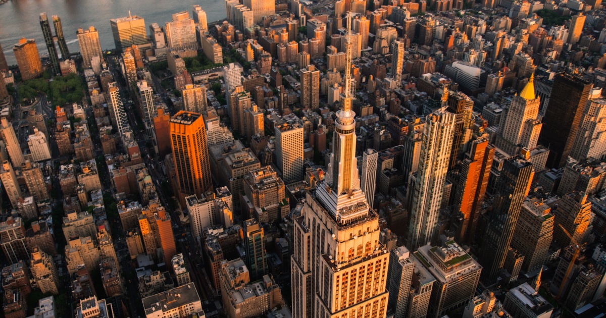

Arthur Ashe Stadium, home to the U.S. Open, sits on ground that is dropping at 4.6 millimeters every year. That rate is slow enough to be invisible and fast enough, over decades, to fundamentally change the flood exposure of one of the most densely populated urban areas on the planet.
The stadium’s sinking is not a standalone anomaly. It is a precise symptom of a city-wide phenomenon that researchers have spent the last several years mapping in unprecedented detail. New York City is sinking beneath the combined weight of its own infrastructure, accelerated by ancient geological forces that no amount of engineering can reverse, and the math of what happens when a sinking city meets rising oceans is becoming harder to ignore.
The ground the city sits on has been slowly settling since the end of the last ice age, roughly 24,000 years ago, when an ice sheet more than a mile high covered much of New England. As that ice melted, the land it had pushed down began rebounding – but New York, which sat just outside the ice sheet’s edge, has instead been gradually subsiding as part of that same geological rebalancing act. Add to that the sheer mass of 1,084,954 buildings pressing down on soils ranging from solid bedrock to soft artificial landfill, and the result is a city in measurable, ongoing descent.
How Fast New York City Is Sinking – and Where It’s Worst
Mapping vertical land motion across the New York City area, researchers found the land sinking by about 0.06 inches, or 1.6 millimeters, per year on average. That headline figure, produced by lead author Brett Buzzanga and colleagues from NASA’s Jet Propulsion Laboratory and Rutgers University, masks wide variation across the five boroughs. A study published in Nature Cities in May 2025, led by Leonard Ohenhen, a postdoctoral researcher at Columbia Climate School’s Lamont-Doherty Earth Observatory, revealed that in every city studied, at least 20% of the urban area is sinking – and that “over time, this subsidence can produce stresses on infrastructure that will go past their safety limit.”
The NASA-JPL and Rutgers study, published in Science Advances, analyzed upward and downward vertical land motion across the metropolitan area from 2016 to 2023 using a remote sensing technique called interferometric synthetic aperture radar, or InSAR. InSAR combines multiple 3D satellite observations of the same region to detect surface motion. The resolution achieved was fine enough to identify subsidence patterns block by block, and what the data revealed in specific locations is striking.
LaGuardia Airport’s runway 13/31 is sinking at 3.7 millimeters per year. The airport is now undergoing renovation partly to alleviate flooding from the rising waters of the Atlantic Ocean. That $8 billion renovation is being built, in part, on a foundation that continues to shift beneath it. The second major hotspot is Arthur Ashe Stadium in Queens, where the U.S. Open is held annually. When the stadium was first built, it was outfitted with a lightweight cloth roof because the sinking land beneath it could not support the weight of a regularly constructed roof, according to lead researcher Brett Buzzanga.
Both the runway and the stadium were originally built atop landfill, which explains the higher-than-average rates. Other subsidence hot spots include the southern portion of Governors Island, built on 38 million square feet of rock and dirt from early 20th-century subway excavations, as well as sites near the ocean in Brooklyn’s Coney Island and Arverne by the Sea in Queens that were built on artificial fill.
The Geology Underneath the City
The variation in sinking rates is largely a product of what lies beneath each neighborhood. New York is built on a surprisingly complex geological foundation. Some parts of Manhattan sit atop extremely hard bedrock, where foundations are anchored directly into strong rock formations that can better withstand the weight of skyscrapers. Midtown Manhattan’s skyscrapers are largely built on rock, which compresses very little, while some parts of Brooklyn, Queens, and downtown Manhattan are on looser soil and sinking faster. Large portions of Lower Manhattan and sections of Brooklyn were constructed on artificial fill – land expanded over centuries using mixtures of sand, soil, rubble, and other materials to create new waterfront terrain. When heavy buildings are placed on softer soils, compression occurs more easily, and the ground settles under the pressure.
The buildings themselves contribute meaningfully to localized sinking. Geologists calculated that New York’s more than one million buildings add up to a total mass of 762 billion kilograms of downward pressure on the earth. According to a 2023 study in Earth’s Future, more than 8 million people live in a city observed to be sinking 1 to 2 millimeters per year, and the modeling of building loads on varied soil types suggests a subsidence potential of up to 600 millimeters in the most vulnerable locations.
The Role of Tectonic Forces – and Why Buildings Aren’t the Whole Story
Tom Parsons, lead researcher at the U.S. Geological Survey, has said parts of the city will eventually be under water. “It’s inevitable. The ground is going down, and the water’s coming up. At some point, those two levels will meet,” said Parsons, whose job is to forecast hazardous events from earthquakes and tsunamis to incremental shifts of the ground below us. The city is not imminently threatened by ocean inundation, but the ongoing process compounds flood risk from individual storm events in ways the city has already experienced firsthand.
The primary driver of subsidence in New York is not the buildings at all. About 24,000 years ago, a vast ice sheet extended over most of New England, with a sheet of over a mile in height enveloping present-day Albany. Since then, the Earth’s surface has been gradually readjusting, and New York City, on land that was elevated outside the edge of the ice sheet, is presently undergoing subsidence because of this glacial isostatic adjustment. That process, sometimes called post-glacial rebound in reverse, cannot be stopped by redesigning buildings or reducing construction density.
Broad subsidence of 1.6 millimeters per year is consistent with glacial isostatic adjustment to the melting of the former ice sheets, though previously undocumented hot spots of both subsidence and uplift also exist and can be physically explained in some locations. Human interventions – including groundwater extraction – can accelerate the natural baseline, which is why some neighborhoods sink faster than geology alone would predict.
A Problem Far Larger Than New York City Sinking
New York’s predicament is shared by nearly every major coastal city in the United States. Published in Nature Cities, a study led by Leonard Ohenhen used satellite-based radar measurements to create high-resolution maps of subsidence for 28 of the most populous U.S. cities, home to 34 million people. In every city studied, at least 20 percent of the urban area is sinking, and in 25 of 28 cities, at least 65 percent is sinking.
In separate research published in PNAS Nexus, Virginia Tech and U.S. Geological Survey scientists measured how much land along the East Coast has sunk and identified which areas, populations, and critical infrastructure are at risk. Subsidence can undermine building foundations; damage roads, gas, and water lines; cause building collapse; and worsen coastal flooding, especially when paired with sea-level rise.
Researchers found that along the East Coast, between 77% and 99% of interstate highways, 81% to 99% of railway systems, and more than 800,000 properties are exposed to risks from subsidence. Particularly affected population centers include New York City and Long Island, Baltimore, and Virginia Beach and Norfolk, where rapid subsidence increases risk to roadways, runways, building foundations, rail lines, and pipelines.
The global picture is no less troubling. High-resolution vertical land motion and elevation data combined with projections of sea-level rise for 32 major U.S. coastal cities show that a considerable amount of land area, population, and properties are threatened by relative sea-level rise by 2050, according to research published in Nature. Dozens of the world’s most populous coastal cities have areas sinking faster than sea levels are rising, meaning subsidence is outrunning the ocean’s advance in city after city.
The Collision Course: Sinking Land Meets Rising Seas
Sea levels around New York have already been rising faster than the global average, and scientists project that waters surrounding the city could rise between 8 and 30 inches by 2050. When sinking land and rising water occur simultaneously, the relative increase in flood risk grows substantially, because each process compounds the other’s effect on ground-level elevation.
Regional relative sea level rise is exacerbating flooding hazards in the coastal zone. Vertical land motion is a driver of spatial variation in sea level change that can either diminish or enhance flood risk. According to the New York State Climate Impacts Assessment, sea level at the Battery in lower Manhattan is projected to increase 14 to 19 inches by the 2050s. Lower Manhattan is particularly exposed because of its elevation. According to Global News, much of Lower Manhattan sits only one to two meters above current sea level – a margin that shrinks further as the land beneath it continues to drop.
The historical record shows what that combination can produce. Hurricane Sandy in 2012 demonstrated what enhanced flood risk looks like in practice, when a 2.7-meter storm surge inundated lower-lying neighborhoods and overwhelmed the city’s coastal defenses, according to earth.org. In 2021, Hurricane Ida delivered another blow of a different kind: according to New York City health data, record-breaking rainfall of 3.5 inches per hour fell in some areas, more than double the sewer system’s capacity of 1.75 inches per hour, sending floodwaters into subway stations and basement apartments.
Both storms struck a city that was slightly lower than it was the decade before, and will strike again, if they do, a city that will be lower still.
The Infrastructure Damage Bill Is Already Being Calculated
Researchers are no longer just mapping where New York is sinking. They are starting to price what sinking means for the built environment. A study in the International Journal of Applied Earth Observation and Geoinformation from Virginia Tech researchers shows that cumulative and uneven ground motion can significantly increase the probability of infrastructure damage over time. Using nearly a decade of satellite radar observations, the team developed a probabilistic framework that translates shifting ground into engineering-relevant damage metrics, projecting outcomes over the next 30 to 50 years.
Under continued deformation, the researchers estimate economic consequences could exceed $18 billion, affecting approximately 3.8 miles of subway lines and 4.8 miles of highway. Results show that even slow subsidence, if left unaddressed, can quietly accumulate into serious operational and safety challenges, especially for airports and major transportation corridors.
Subways, highways, and major airports, including JFK and LaGuardia, are among the most exposed assets. The subway system alone serves millions of daily riders across hundreds of miles of tunnel and track, much of it at or below sea level. The integrity of that network depends on ground that is moving.
You can read more about how climate-driven environmental changes are reshaping cities and communities in the coming decades in 2050: The World We’ll Inherit if Climate Change Continues Unchecked.
“The latent nature of this risk means that infrastructure can be silently compromised over time with damage only becoming evident when it is severe or potentially catastrophic,” said Associate Professor Manoochehr Shirzaei at Virginia Tech’s Earth Observation and Innovation Lab. “This risk is often exacerbated in rapidly expanding urban centers.” Ntambila Daud, the lead author of the Virginia Tech infrastructure study and a researcher at Virginia Tech and Ardhi University, put it plainly: “This is the kind of information infrastructure managers actually need to plan ahead,” according to Virginia Tech News.
Read More: Warning Issued As Major American City Continues Sinking, Putting Human Life ‘At Risk’
What to Do With a City That’s Sinking
New York City is sinking at an average of 1.6 to more than 2 millimeters per year across 98% of its land area – a rate driven primarily by ancient glacial geology and secondarily by the weight of over a million buildings bearing down on varied and often soft urban soils. Specific hotspots like LaGuardia Airport and Arthur Ashe Stadium are sinking at rates two to three times that average, largely because they sit on unstable landfill. Neither the glacial forces nor the geological composition of the city’s foundation can be engineered away. That fact narrows the realistic range of responses considerably.
Lead study author Leonard Ohenhen has urged that “city planners must acknowledge that land subsidence is not a write-off issue, but a critical amplifier of flood risk and infrastructure vulnerability in cities,” emphasizing “investments in vulnerable areas, implementing zoning regulations in high-risk zones, and designing infrastructure such as roads, drainage systems, and coastal defenses with projections of future ground elevation changes in mind.” Sea level projections of 14 to 19 additional inches by the 2050s mean that the risk calculus for every piece of low-lying infrastructure in the city is shifting, whether or not the ground beneath it moves another millimeter. The most actionable response, researchers agree, is accelerating subsidence monitoring, directing infrastructure investment toward the highest-risk zones, and building coastal defenses that account not just for rising seas but for the falling land beneath them.
AI Disclaimer: This article was created with the assistance of AI tools and reviewed by a human editor.