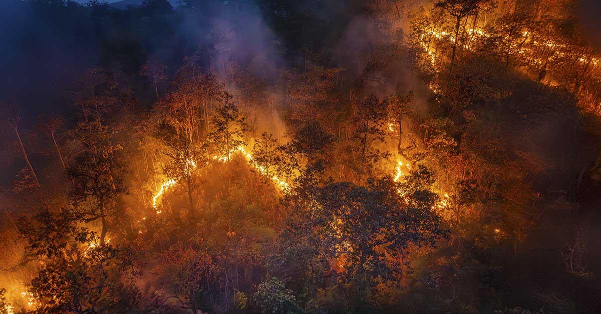

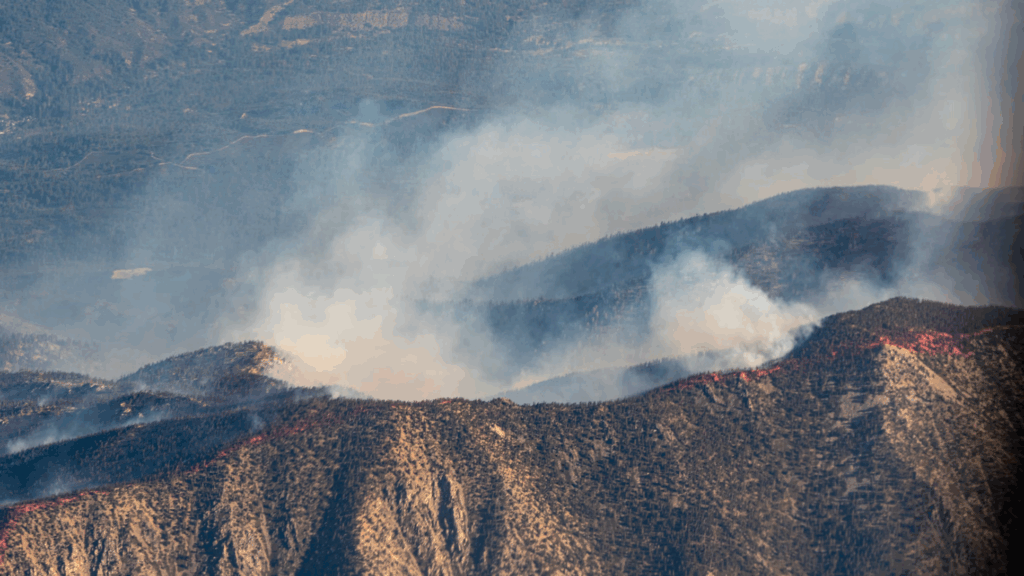
Powerful wildfires swept through Southern California in January 2025, causing an estimated $250-275 billion in total damage and economic loss. Experts now warn these fires hint at an even more dangerous wildfire season ahead. Recent forecasts predict that flames will consume between 7 and 9 million acres across the United States this year. About 60,000 to 75,000 fires will ignite nationwide. These numbers show the growing wildfire crisis that threatens communities across the country.
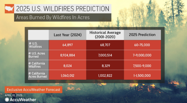
Forecasters project California alone will face 7,500 to 9,000 wildfires this year. Since January, flames have already scorched nearly 60,000 acres across 653 separate wildfires in the state. The January fires damaged many communities. The Palisades Fire burned through 23,707 acres, ranking as the third-most destructive wildfire in California’s history. Meanwhile, the Eaton Fire consumed 14,021 acres, becoming the second-most destructive and fifth-deadliest wildfire the state has ever faced.
High-Risk Regions: Where Danger Lurks
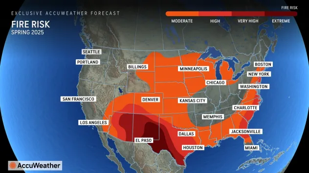
As summer approaches, wildfire risk threatens several regions with particular intensity. The southern Plains and parts of the interior Southwest currently face “elevated to extreme” wildfire dangers as drought conditions worsen. These spring fires create threats, especially in areas emerging from winter drought where dry vegetation readily fuels flames.
Unexpectedly, Hurricane Helene’s path now presents another fire hazard. The storm damaged areas from northern Florida into the Appalachians last September. It left behind loads of dead vegetation that creates perfect conditions for rapid fire spread. “Dry stretches with below-normal thunderstorm activity can lead to temporary flare-ups, especially in the Carolinas, parts of Georgia, Florida and the Gulf Coast,” meteorologists report.
Lingering winter moisture will initially limit fire potential in the West. However, climate experts warn danger will spike dramatically as summer heat intensifies. Areas east of the Cascades through the northern Rockies face especially concerning conditions during this year’s wildfire season. “While the season may start slowly, there is strong potential for rapid escalation as drought conditions and heat set in,” according to a senior meteorologist with the National Weather Service.
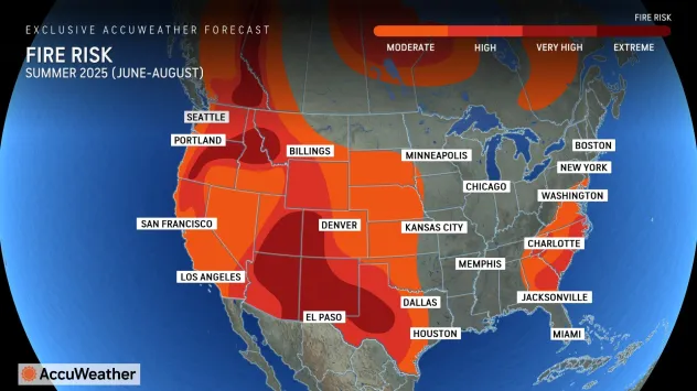
Fire prediction models forecast above-normal fire potential will threaten the southwestern U.S., southern California, and southern Nevada in June. By July, this danger zone will expand into more of California and the northern Great Basin. At the same time, monsoon rains will bring limited relief to the Four Corners region.
Read More: Antarctica’s Ozone Layer Shows Strong Signs of Recovery, Scientists Say
Why This Year’s Wildfire Season Is Different: The Drought Connection
Drought creates ideal conditions for wildfires. When landscapes lose moisture, plants and trees dry out and become highly flammable. This makes fires start more easily and spread much faster. Several key factors work together to determine fire risk: high temperatures, dry soil, low humidity, strong winds, and the amount of available burnable vegetation. These conditions control both how often fires begin and how destructive they become.
Drought now affects approximately 45% of the country. Since October 2024, droughts have spread to an additional 20% of California and Nevada. Government monitoring systems show new areas falling into Extreme or even Exceptional Drought categories, the most severe classifications possible.
Climate factors amplify these risks significantly. Recent shifts from El Niño to La Niña conditions have redirected moisture away from Southern California. Storm systems now move predominantly toward the Pacific Northwest instead. By late December 2024, moderate drought conditions had spread across most of Los Angeles County. This created heightened fire vulnerability as vegetation dried out during what should have been the region’s wet season.
Shifting weather patterns worsen this situation by creating volatile conditions across fire-prone regions. Even short rain periods can backfire. They spur vegetation growth that quickly dries into large amounts of fuel during long heat waves. Recent studies show climate change has increased the overlap between hot, dry weather and offshore wind seasons. This creates a perfect storm of wildfire season danger.
Read More: Experts Warn Undersea Volcano Could Erupt Soon—Here’s What We Know
Fighting Back: How Communities Are Preparing for Wildfire Season
As threats grow, fire management teams now focus on both prevention and aggressive response. Forest managers thin overgrown areas and conduct strategically planned burns to reduce fuel loads before they can feed wildfires. If you live in a high-risk area, you should create defensible spaces around your home right away. This strategy requires clearing all flammable vegetation within 30 feet of buildings. You should also install fire-resistant landscaping and regularly maintain your roof and gutters to prevent ember ignition.
Communities are actively upgrading early warning systems and refining evacuation plans as dangers increase. Officials issue Red Flag Warnings, like the recent alert for northwestern Minnesota, to signal extreme fire risk conditions. “Any spark could become a wildfire under Red Flag conditions,” cautions a wildfire prevention specialist with a state natural resources department.
Fire agencies strategically position resources as conditions worsen across fire-prone regions. For example, when the Iron Fire erupted in New Mexico’s Gila Wilderness on May 4, responders immediately deployed multiple helicopters, engines, and specialized hotshot crews to attack the blaze before it could expand.
Looking Ahead: What This Year’s Wildfire Season Means
Intensifying wildfire seasons demand a fundamental shift in how communities approach their fire risk. What once represented seasonal concerns now requires year-round caution. Fire seasons start earlier and burn longer than in previous decades.
Vulnerable regions must adapt immediately. Officials need to change building codes to require fire-resistant materials. They should invest in community-wide alert systems and develop more robust evacuation plans. You should prepare thoroughly by creating detailed home inventories for insurance purposes. Also, consider assembling emergency go-bags before fires threaten your area.
Changing fire patterns demands new approaches to forest management. Recent research challenges the traditional “active day, quiet night” firefighting model. It reveals how drought conditions drive overnight burning, a key mechanism behind the largest, most destructive fires.
As wildfire risks grow, effective solutions will require both household preparedness and community-wide planning. The 2025 fire season highlights how climate change is intensifying these disasters. This makes adaptive strategies critical for long-term safety.
Read More: How Certain Birds of Prey Deliberately Ignite Wildfires