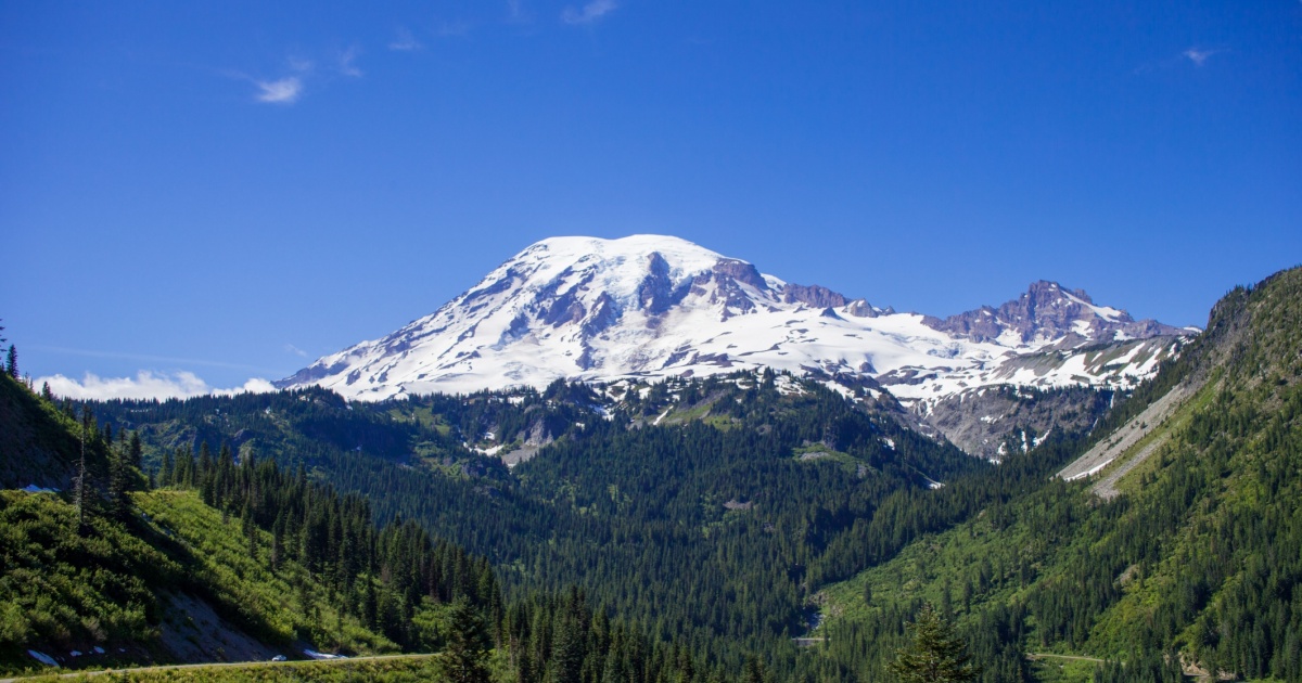

There’s a beautiful mountain in Washington State that most Americans drive past, hike around, and photograph for their Instagram feeds without giving much thought to what lies beneath. It’s picture-perfect: a snow-capped peak rising dramatically above the Pacific Northwest’s green valleys, glaciers glinting in the sun, rivers running clear and cold from its flanks. But scientists have been paying much closer attention to this mountain lately, and what they’re watching has them genuinely concerned.
The threat is real, the affected communities are densely populated, and the timing is unknown. What’s becoming clearer to researchers, though, is that when the danger arrives, it may come with almost no warning at all.
That mountain is Mount Rainier. And according to experts, it’s not just one of the most impressive natural landmarks in North America. It holds the unwelcome title of America’s most dangerous volcano.
What Makes Mount Rainier So Dangerous
Although Mount Rainier has not produced a significant eruption in the past 500 years, it is potentially the most dangerous volcano in the Cascade Range because of its great height, frequent earthquakes, active hydrothermal system, and extensive glacier cover. That combination, sitting directly upstream of a sprawling, densely populated region, is precisely what worries scientists most.
Because of its elevation, relief, hydrothermal alteration, icecap, glacier-fed radial valleys, and proximity to the suburbs of the Seattle-Tacoma metropolis, Mount Rainier is considered the most threatening volcano in the Cascades. The USGS National Volcano Early Warning System classifies it as a “Very High Threat” volcano, based on the types of hazards it poses and its proximity to people, property, and infrastructure.
According to the USGS, the mountain stands at 4,392 meters (14,410 feet) in the Cascade Range, towering above the Puget Lowlands. With 26 major glaciers and 36 square miles of permanent snowfields and glaciers, it is the most heavily glaciated peak in the lower 48 states. Those glaciers contain more than five times as much snow and ice as all the other Cascade volcanoes combined. If only a small part of that ice were melted by volcanic activity, it would yield enough water to trigger enormous lahars. A lahar is a fast-moving mixture of volcanic debris, rock, and water that flows like liquid concrete. It can destroy everything in its path, and it moves fast enough that escape is not guaranteed.
The Lahar Threat: No Eruption Required
Here’s the part of the Mount Rainier story that surprises most people. You don’t need a volcanic eruption to trigger a lahar. Scientists say the most lethal threat from the mountain may not come from fire and ash, but from a rapidly moving mudflow that could destroy nearby communities in minutes.
Lahars can also occur under non-eruptive conditions, such as when rock underlying part of the volcanic structure has been sufficiently weakened by past eruptions and then spontaneously fails, leading to a landslide that transforms into a lahar. That’s not theoretical. As the USGS Cascades Volcano Observatory notes, one of Rainier’s most recent far-traveled lahars originated from an avalanche of hydrothermally altered rock from the volcano’s upper west flank about 500 years ago with no known triggering eruption – a scenario scientists call a “no-notice lahar.”
What that means practically: communities downstream have no guarantee of the early warning signals that typically precede a volcanic eruption. A lahar triggered by a landslide could be underway before anyone realizes anything unusual is happening.
The largest and most fluid lahars can flow over 100 miles per hour on Mount Rainier’s steep slopes, slowing to 15 to 20 miles per hour as they spread across the Puget Lowlands. Lahars look and behave like flowing concrete, and they destroy or bury most man-made structures in their paths.
A large mudslide from Mount Rainier could reach Orting and other affected towns in just 30 minutes and affect more than 60,000 residents. The towns of Orting, Puyallup, and Sumner sit directly in the river valleys that flow from the mountain’s flanks. About 80,000 people and their homes are at risk in Mount Rainier’s lahar-hazard zones. Key infrastructure such as major highways and utilities runs through these zones, which also contain economically important businesses, hydroelectric dams, and major seaports.
A History of Destruction
Rainier’s lahar history is not a matter of speculation. The mountain has done this before, repeatedly, and on a scale that is hard to imagine.
Large Mount Rainier lahars have flowed as far as the Puget Lowlands, a distance of about 50 kilometers, at least 11 times in the past 6,000 years, according to the USGS significant lahars page. During that same period, large lahars have reached the Puget Sound lowland on average at least once every 500 to 1,000 years. The most catastrophic of those events, the Osceola Mudflow, occurred roughly 5,600 years ago. During that event, a massive chunk of the volcano’s summit collapsed, and the resulting debris avalanche produced a mudflow that reached as far as present-day Tacoma and south Seattle. The avalanche removed the top 1,600 feet of Rainier, dropping its height significantly.
The more recent Electron Mudflow, which swept down Rainier’s west flank approximately 500 years ago, gives a clearer picture of what modern communities face. According to USGS Holocene eruption records, around 530 to 550 years ago the Electron Mudflow began as an avalanche of hydrothermally altered rock from the mountain’s west side, with no clear evidence linking it to an eruption. Historical records show that flow traveled 34 miles and reached depths of more than 26 feet where it was confined in valleys. The flat floor of the Puyallup River valley near Orting today is formed by the deposits that event left behind – ground that is now home to thousands of residents and their families.
Geologists often point to the 1985 disaster at Colombia’s Nevado del Ruiz volcano as the closest modern comparison. The eruption there quickly melted summit glaciers, and fresh floodwaters rapidly entrained loose sediment on the volcano’s flanks. This set off a series of lahars that rushed down toward the town of Armero as its residents slept. According to USGS records of the Armero tragedy, that event claimed more than 23,000 lives when lahars inundated the town. Rainier’s glaciers are far larger than those of Nevado del Ruiz.
If you want to understand more about natural disasters and long-term health, the research on community preparedness has grown significantly in recent years.
The 2025 Seismic Swarm
Awareness of Rainier’s threat sharpened considerably in the summer of 2025. According to the USGS Cascades Volcano Observatory, an earthquake swarm that started at Mount Rainier on July 8, 2025, became the largest ever recorded at the volcano. The 2025 swarm produced the largest number of events, highest rate of events, and largest amount of energy released since monitoring began in 1982.
The swarm resulted in over 1,350 located earthquakes and thousands of additional earthquakes too small to locate. When the swarm began, it quickly reached a maximum rate of about 40 earthquakes per hour. The Volcano Alert Level and Aviation Color Code for Mount Rainier remained at NORMAL/GREEN throughout the swarm, as the activity was related to the volcano’s hydrothermal system – the underground network of hot water and gases interacting with heat from the volcano. Despite the levels of seismic activity, the USGS Cascades Volcano Observatory’s final update found no sign of magma movement or volcanic unrest, and instead attributed the swarm to underground fluids shifting through cracks deep below the mountain.
Scientists were clear: the swarm was not a sign of an imminent eruption. But it served as a reminder that this mountain is very much alive, and that its underground systems are active. Volcanologist Jess Phoenix, a science communicator and volcanic hazards expert, put it plainly: “Mount Rainier keeps me up at night because it poses such a great threat to the surrounding communities.”
Read More: ‘Zombie Volcano’ Awakens After 250,000 Years
What Are the Odds, and What’s Being Done
Geologists consider Mount Rainier the most dangerous mountain in the United States, and the USGS has estimated there is a one-in-seven chance of a catastrophic lahar at Mount Rainier occurring in the next 75 years. That may not sound alarming at a glance, but in geological terms, those are not comfortable odds for a hazard that could level entire towns within half an hour.
To address the risk, authorities have built one of the more robust early warning systems in the country. The Mount Rainier Lahar Detection System was established in 1998 to give downstream communities tens of minutes of warning in the event of the next large lahar. The system has since been significantly expanded. The result of a 20-year technology improvement effort is a robust lahar detection system that operates in real time, sending detection information to two emergency operations centers staffed 24/7, one run by the state of Washington.
On the ground, according to Pierce County Emergency Management, tens of thousands of people live in areas that may have as little as 40 minutes, or as much as three hours, to move to safety once a large lahar is detected. The system is built to be robust, warnings are disseminated promptly and widely, and people in harm’s way are taught how to respond. Pierce County also operates warning sirens positioned throughout the Puyallup and Nisqually River valleys, the two corridors considered most vulnerable to lahar flow.
Evacuation in lahar zones requires residents to move uphill and quickly. For communities like Orting, which sits in a bowl-shaped valley with limited exit routes, those sirens and the minutes they buy could be the difference between life and death.
What This Means for You
If you live in the Pacific Northwest, or plan to travel through Pierce County and the areas surrounding Mount Rainier National Park, the first step is knowing whether you’re in a lahar hazard zone. Pierce County Emergency Management maintains updated evacuation maps and hazard information, and understanding your specific risk level takes only a few minutes to check.
For those outside Washington State, the broader lesson from Mount Rainier is about the gap between perception and actual risk. Yellowstone grabs headlines, Mount St. Helens is the name people remember from 1980, but ask a volcanologist where the real risk in the U.S. lurks, and there’s a good chance they’ll point to the Cascades, where America’s most dangerous volcano sits as a postcard-perfect natural wonder that causes scientists genuine concern. The USGS continues to monitor the mountain around the clock, and while no eruption appears imminent, the scale of potential impact from a lahar means that preparedness at the community and individual level remains one of the most important things residents can act on right now. Check your evacuation route, know the siren signal, and understand that in Rainier’s valleys, moving uphill fast is the plan that matters most.
AI Disclaimer: This article was created with the assistance of AI tools and reviewed by a human editor.
Read More: Ticking Time Bomb: The Largest Supervolcano In The US Is Awakening