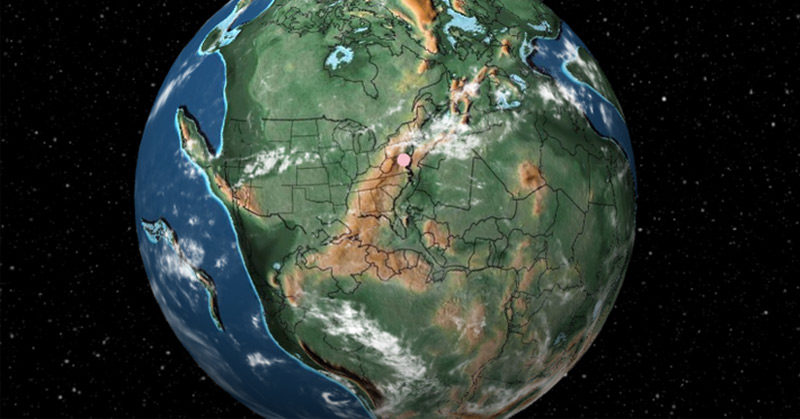

The Earth has changed a lot. This interactive globe displays the world as it has been from today to 750 million years ago. It displays the continental drift that occurred as land formed into the map we are familiar with today. To add a personal touch to this journey of the ages, the map allows the user to pinpoint whichever city they choose. This allows them to view the journey of that city as the world evolved. [1]
Ancient Earth, the Interactive Digital Map
Co.Design partnered with the globe engineer and Google alum Ian Webster and Paleomap Project creator C.R. Scotese to create the page, which they called Ancient Earth. The map contains geographical information scientists have discovered about the past 750 million years.
Here’s a tip: Skip to the farthest back you could go then watch as the world shapes into the one we know. You can also enter your city or street address to see where it would have been in each time era. For instance, New York was just a small island in the southern hemisphere five million years ago. At that time, London was still a part of Pangaea, almost on top of the South Pole. [2]
Pangea was the ancient supercontinent formed by other continental units, all surrounded by oceans. Then, scientists believe about 175 million years go, magma began to push this supercontinent in varying directions until the globe had the seven continents we live on today. [3]
You could use the arrow keys on your computer to flip through one era to the next and read about each event that had taken place there, like the mass wipeout of dinosaur life and the emerging of coral reefs. You will see that Pangaea didn’t split into the seven continents so easily. There have been several lost continents that disappeared during the evolution.
Read: Boy Accidentally Finds 66-Million-Year-Old Dinosaur Eggs
No Map Depicting The Earth Millions of Years Ago is Perfect
Although these global images are very interesting, Webster states that their maps are only approximate. “Even though plate tectonic models return precise results, you should consider the plots approximate (obviously we will never be able to prove correctness),” he wrote on Hacker News. “In my tests, I found that model results can vary significantly. I chose this particular model because it is widely cited and covers the greatest length of time.” [4]
In comments to his post, he adds that the maps have incited some angry geologists because his maps don’t advance their theories. As he said, it’s impossible for anyone to prove exactly how the world was that long ago, but his work is a beautiful way of exploring what the past might have been. Click here to begin.
Read: There are Ancient Ruins Older Than The Pyramids In Canada
More about Pangaea and the Earth Millions of Years Ago
One theory suggests that Pangaea was formed as the Earth’s outer shell was broken into several plates that slide over the mantle, the rocky shell in the Earth. The ocean surrounding this supercontinent was called Panthalassa. As eras passed, more supercontinents formed and broke away because of the movement in the mantle. This slow formation caused and altered history on this planet.
“This is what’s driven the entire evolution of the planet through time. This is the major backbeat of the planet,” said Brendan Murphy, a geology professor at the St. Francis Xavier University, in Antigonish, Nova Scotia.
Over a hundred years ago, scientist Alfred Wegener introduced the idea of a supercontinent named Pangea, or also written as Pangea. He came to this conclusion after discovering that our seven continents fit together like puzzle pieces. Also, there are geologic reasons, such as coal deposits in Pennsylvania have an alike composition to the ones in Poland. This shows that America and Europe could have been connected to one mass of land.
Life on Pangaea
One huge landmass created a very different climatic cycle we know of today. For instance, it’s believed that the center of Pangaea was hot and desert-like since it was trapped between massive mountain ranges. The weather was extremely seasonal according to a 2016 article in the journal Palaeogeography, Palaeoclimatology, Palaeoecology. The researchers came to this conclusion using biological and physical data from the fossil soils in northern Niger. They used this to reconstruct the ecosystem and climate that could have been on Pangaea.
During this time, several animals flourished, including ancestors of the mammals we know of nowadays. Its fauna also included insects like beetles and dragonflies. [6]
Researchers deduce that the world is not done shifting and it’s likely the Earth will eventually split off into different continents once again. Right now, Australia seems to be moving toward Asia and eastern Africa seems to be drifting away from the rest of Africa. It’s hard to track some large movement in such a short period of time but Ancient Earth can give us a clue as to how the plant had changed in the past.
[1] “This Map Lets You Plug in Your Address to See How It’s Changed Over the Past 750 Million Years.” Meilan Solly. Smithsonian Magazine. February 15, 2019
[2] “Interactive Map Shows Where Your House Would Have Been 750 Million Years Ago.” Michele Debczak. Mental Floss. June 20, 1028
[3] “This map shows how your city moved over the last 750 million years.” Jesus Diaz. Fast Company. June 18, 2018
[4] “Interactive Map Plots Your Address Over 750 Million Years of Earth’s History.” Michael d’Estries. Tree Hugger. May 1, 2020
[5] “Facts About Pangaea, Ancient Supercontinent.” Tia Ghose. Live Science. February 23, 2018