

Northwestern Australia is a dry and barren region, home to the Gibson Desert, the Great Sandy Desert, and the Great Victoria Desert. There is so much for researchers to explore there, but a recent study made a discovery beyond the arid ecosystem. This part of the continent used to be occupied by an ancient civilization before being consumed by the sea.
647,000 square km of land
According to a study in Quaternary Science Reviews, researchers have found artifacts and indicators of human life on a sea shelf off the coast of New Guinea, which is an island north of Australia. Scientists believe that the now-drowned landmass of almost 647,000 square kilometres used to be a well-populated ecosystem during the Late Pleistocene period. “We’re really looking at a landmass that was about 1.6 times the size of the UK,” Norman said.
Sustaining 50,000 to 500,000 people

The research showed that the shelf may have once had a desert climate with freshwater and saltwater lakes and rivers that could have sustained 50,000 to 500,000 people. “It’s important to bear in mind these aren’t real population numbers we’re talking about, it’s just a matter of projecting the carrying capacity of our landscape,” said Kasih Norman, an archeologist at Griffith University in Queensland, Australia, and lead author on the new study, to Live Science. “We’re basically saying it could have had that many people.”
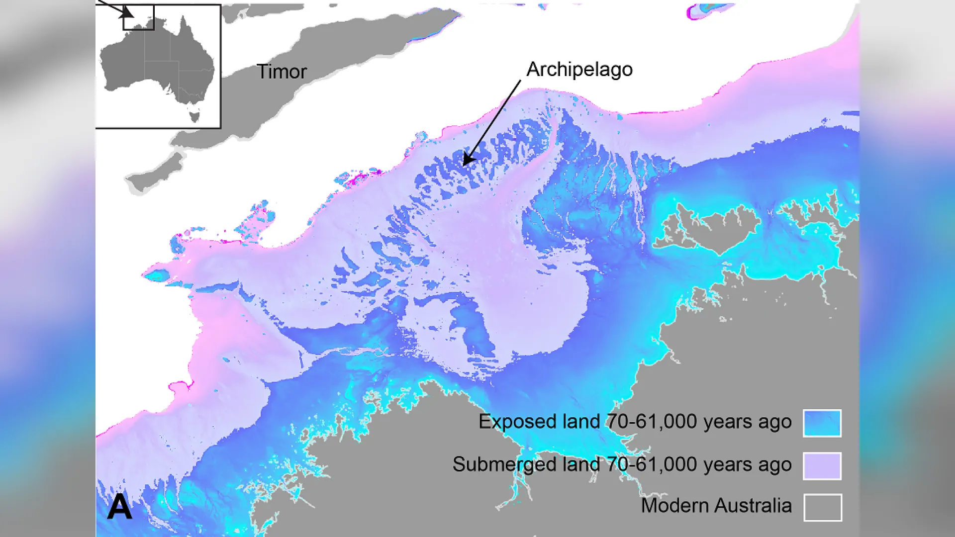
Linking Australia to New Guinea

The shelf may have even bridged New Guinea to Australia, creating the supercontinent known as Sahul. However, about half of the shelf was taken over by rising sea levels. “We’re talking about a landscape that’s quite submerged, over 100 meters [330 feet] below sea level today,” said Norman.
“This likely caused a retreat of human populations, registering as peaks in occupational intensity at archaeological sites,” the scientists wrote.
Connecting cultures

Before the study, researchers have known that the northwest continental shelf connected Kimberley and western Arnhem Land. This shelf is currently underwater, but the archeologists found many stone tools that indicate human settlements around the area. During this period of 65,000 years, the shelf likely linked colonies with similar cultures, languages, art styles, and technology. For example, Kimberley and Arnhem Land displayed similar trends in their styles and subjects of cave art. This included more depictions of humans. Norman believes this could be inspired from new settlers joining the colonies.
Not so alone

This is groundbreaking since researchers once believed Australia’s continental shelves offered no use to the First Nations. But now, these areas are showing clear signs that they were once occupied. “There’s been an underlying assumption in Australia that our continental margins were probably unproductive and weren’t really used by people, despite the fact that we have evidence from many parts of the world that people were definitely out on these continental shelves in the past,” Norman said.
Mapping the northwest shelf of Sahul

In the new study, archeologist Kasih Norman and her team mapped sea levels onto ocean floor maps to recreate the topography of the northwest shelf of Sahul. As it turns out, lowered sea levels revealed a group of islands that might have helped settlers come to Australia from Indonesia.
The exposed land “would have meant that there was basically a contiguous archipelago environment to move from the Indonesian archipelago, across to Sahul, and then from that archipelago into the supercontinent itself,” Norman said.
“The rise in undersea archaeology in Australia”

There is so much to discover about this lost piece of history. Therefore, the researchers plan on continuing delving into this landscape. “Now submerged continental margins clearly played an important role in early human expansions across the world,” the study states. “The rise in undersea archaeology in Australia will contribute to a growing worldwide picture of early human migration and the impact of climate change on Late Pleistocene human populations.”
Diving deeper on the Australia sea shelf

Norman hopes this study will encourage other people to examine the archaeology of this Australian shelf. “It’s quite fascinating to look at how people dynamically responded to events in the past and obviously survived them and thrived,” concluded Norman. “I would hope that there might be something we can take from that, that we can apply to future climate change and sea level rise in the next few hundred years.”
Read More: Gorillas Seen Self-Medicating By Using Same Antibacterial Plants As Traditional Healers